
Hydroacoustics - a tool for studying water areas
Hydroacoustics - a tool for studying water areas
The centuries-old history of human society, its entire path to progress is closely connected with the ocean — with navigation, with the development of its huge food, raw materials, and later, fuel and energy resources. ‘ Very soon, the Ocean may be associated with the problem of the very existence of mankind,’ — said the famous researcher of the depths of the sea Jacques-Yves Cousteau. ‘Very soon all of us will have to bow to the God of the seas-to ask him to share his wealth with people’, ‘The threat of mineral famine will literally force a person to actively explore the Ocean’, - echoed by scientists academics - geologist V. I. Smirnov and oceanologist L. M. Brekhovskikh. What do we know about the Ocean? The relief of the land has long been reflected in detailed geographical maps, and the relief of the bottom of the vast expanse of the Ocean until recently was only a very rough idea. In 1975, the geological and geophysical Atlas of the Indian ocean was published in the Soviet Union. It has many new detailed maps of the bottom. Oceanologists studied not only the relief, but also the distribution of sediments, the deep structure of the earth's crust, underwater earthquakes, magnetic anomalies. Nowadays, the Ocean is studied in different ways. It is difficult to explore the depths by special devices without reliable communication with the surface. And the radio waves that serve us faithfully on Earth and in space, go out in the water, having overcome only tens or hundreds meters. Replace them until now can only waves of acoustic.
Hydroacoustics
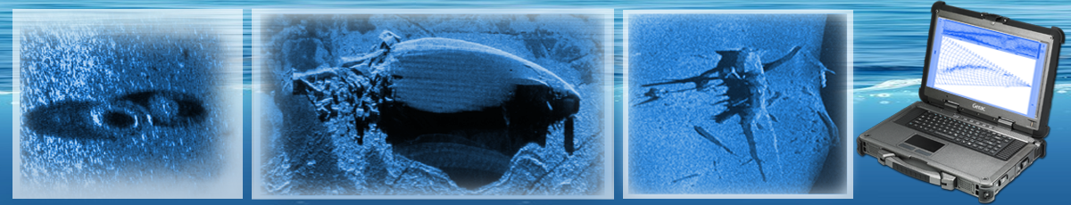
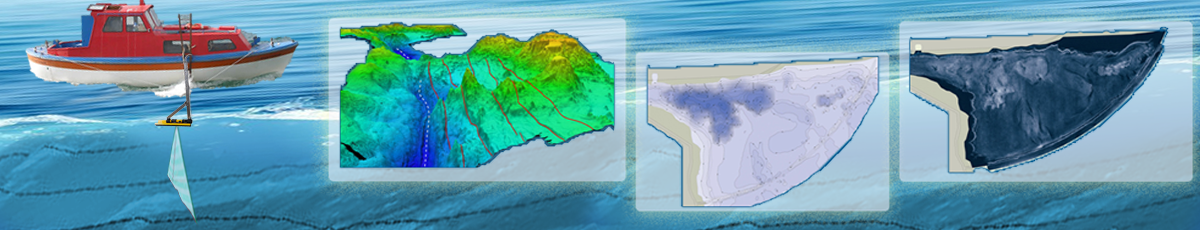
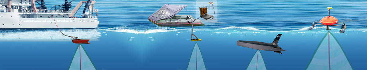
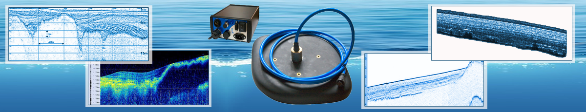
Hydroacoustics deals with the generation, transmission, reception and use of natural sound. Since radio and light waves are largely absorbed by ocean waters, and sound waves are hardly absorbed, sound is used to probe the ocean floor, locate various objects in the oceans, study the nature of sediments, and as a means of communication. The earliest use of underwater sound was the installation of bells submerged under floating beacons and buoys. During periods of poor visibility, the sound of these bells could be detected at great distances by hydrophones mounted in the ship hull. In 1912, Thomas Green Fessenden developed an electromagnetic sound source that allowed communication between ships by underwater signaling using Morse code. The development of the echo sounder was another example of the early use of hydroacoustics. In 1937, for the first time a new method of depth measurement was applied, based on the effect of reflection of the sound signal from the bottom. Depth echo-sounding measurements have changed the previous ideas of scientists about the topography of the ocean floor. Almost all soundings are now carried out by echo-sounders, and the method itself is called the echo-sounding. The speed of propagation of audio signals is usually 1460 m / s (800 fathoms). For accurate depth measurement it is absolutely necessary to have an oscillation source with a strictly defined periodicity of sending sound signals. Otherwise, minor deviations in the periodicity of the signal sending and changes in the supply voltage may affect the synchronicity of the recorder, which will entail significant errors in determining the time between the direct and reflected sound pulse on the echogram. Most echo-sounders currently in use are equipped with built-in stabilizers of the period of the signal sending, which ensures a stable control voltage of the recorders; as a result, an acceptable measurement accuracy is achieved. The echo sounding method does not allow to obtain values of absolute depths with the same accuracy, since the speed of sound passing through the water column is different for different depths. However, repeated probing when the frequency of the signals changes should show the same values. Errors of a different kind while echo-sounding (in older models of echo-sounders ) occur due to the fact that the beam sent by the echo-sounder does not propagate in the form of a narrow vertical beam, but in the form of a cone with a solid angle of about 30°. As a result, in cases where steep slopes are probed, the signal is usually reflected from the point closest to the vessel on the slope, rather than from the bottom surface directly below the vessel. The echo-sounder measures the depth of water under the hull by timing the echo of short sound pulses bouncing off the ocean floor. Initially, the main tasks of sonar were the detection of submarines, determining the range of sound propagation, etc.. Currently, hydroacoustics is a field of applied and scientific research. Sound refraction and reflection are used by geophysicists and marine geologists to study the deep structure of the ocean floor (seismic profiling) and to map the ocean floor (echo-souder measurements). Marine biologists study the sounds made by various forms of marine fauna. The speed of sound propagation is equal to the square root of the ratio of the compressibility of sea water to its density and in the oceans depends on temperature, salinity and pressure (depth). The main influence on the speed of sound renders the temperature. The speed of sound in seawater varies from 1450 to 1570 m / c; it increases with temperature by a variable value of about 4.5 m/c per 1°C; it also increases by 1.3 m/c as the salinity of the water increases by 1 0/00 , and finally it increases with depth by 1.70 m/c for every 100 m. The use of electronic methods for acoustic and seismic studies, as well as for the study of magnetism, gravity heat flow on the oceanic crust is of great importance for the rapid development of marine geology. The development of echo-sounding has prompted specialists engaged in marine underwater surveys to make very detailed maps of continental shelves and slopes. In the 50s, a significant contribution to the development of marine geology was the development and use of seismic profiling by the method of reflected waves, which allowed us to study the nature of structures and formations lying under the surface of the ocean floor. Many continental slopes on the globe have been explored by this method; countless profiles have crossed all the oceans, providing a huge flow of information. Acoustic instruments towed near the seabed provide more accurate terrain profiles than those obtained with instruments mounted on surface vessels. The side scanning method, using onboard or submersible towed instruments (geosonars), makes it possible to cover wide swaths of the bottom on both sides of the moving vessel, so that a three-dimensional picture of the bottom relief can be obtained. Innovations such as satellite navigation and triangulation using a system of submersible buoys equipped with acoustic instruments (transponders) have made significant progress in improving the accuracy of ship positioning. Other electronic navigation devices, as well as ship computers, data storage and processing systems are also used with great success.
Depth measurement methods
Until 1920 all measurements of depths were carried out thus: the sinker suspended on the end of a tench lowered in water; when the sinker reached a bottom (this point was marked on a tench), a tench with sinker pulled out and measured length of a tench. After 1870, the rope tench, whose stretching affected the measurement results, was replaced by a metal cable. To obtain the true depth of the bottom it is necessary that the position of the cable at the time of measurement was close to the vertical. Measuring with a metal cable is also very difficult, even when using high-speed winches and highly maneuverable vessels, from which the descent of the sinker can be carried out at an almost vertical position of the cable. Deep-sea measurement in this way takes hours. There is another method for obtaining a picture of the bottom surface on either side of the ship's route, consisting in the use of sonar, similar to the devices used to detect submarines. The beam of this emitter is directed downward at a slight angle from the surface of the ocean. Seismic profiling by wave reflection method (WRM) is similar to sonar, but uses low-frequency elastic wave pulses instead of high-frequency ones, which are less absorbed when passing through sediments and bedrock layers of the seabed. The boundaries between the layers of sedimentary rocks are obtained in the form of streaks lying under the bottom surface and expressed by the compaction of the recording. This makes it possible to identify the structure of sedimentary layers, determine the depth of the foundation and other important boundaries of the oceanic crust. Also, with the help of seismic studies, it was found, that there is the surface of separation under the oceans, as well as under the continents, below which sound waves propagate at a speed slightly exceeding 8 km/sec, while above this surface their velocity is lower. Academician L. Brekhovskikh developed a detailed theory of sound energy propagation, which he called " underwater sound channel”, and in 1976 he was awarded the State prize together with the team of authors of the monograph “Ocean Acoustics”. The experiments were carried out on the research vessels “Sergey Vavilov " and " Peter Lebedev”, the first floating laboratories specially adapted for this purpose. A similar discovery was also made by the Americans. However, their work was carried out in the strictest secrecy, and the results were not published, probably because of the military orientation of the research. The range of the underwater channels is amazing! The sound of an underwater explosion of one and half kilogram charge in the Atlantic was recorded by instruments in Bermuda, located 4500 km from the site of the experiment. In the air, such an explosion would be heard at a distance of no more than 4 km, and in the forest-no more than 200 m. With the help of waveguides, nuclear tests are currently being recorded. This phenomenon has led experts to a fundamentally new idea of acoustic rescue service: it is enough to blow up a signal grenade to instantly determine the location of an accident or disaster and organize assistance. In addition, the acoustic waveguide got to be very useful for meteorologists: it turns out, underwater receivers can pick up a noise from the epicenter of a hurricane raging hundreds of kilometers from the station. Following the direction and volume of these sounds, it is easy to calculate, in principle, the course of the hurricane, to intercept the echoes of the terrible tsunami, which is especially important for residents of coastal areas — because from Chile to Hawaii tsunami wave passes for 10 hours, and from Chile to Japan - for 20h. A real turtle compared to its sound accompaniment!
Human use of hydroacoustics allows us to explore the Oceans and penetrate its secrets.